53°54'19.4"N 9°73'84.0"E
The Große Brack
The Große Brack or Achterbrack (brackish water pool)
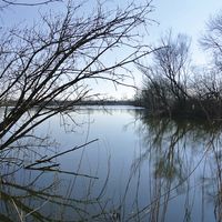
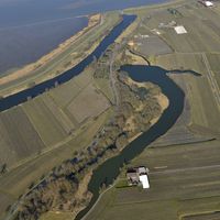
The largest remaining Brack (brackish water pool) in the Altes Land is the Große Brack or Achterbrack. The Hinterbrack district therefore bears its name. It consists of several parts, the large water area in the south-east measures 2,700 m² (without the widening of the Wettern). The water area with marsh and fen landscape measures in total 91,940 m². This area has also undergone major changes due to the new dyke line after 1962.
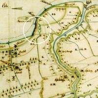
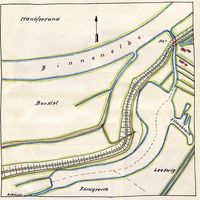
No area in the Altes Land was as threatened by storm surges as this one was. Close below the Brack, the aerial photograph still indicates remains of the protective dyke built in 1757 and running south-east, which at that time extended to the Este and closed off the Cranz - Leeswig - Hinterbrack dyke district from the second mile, however, which today extends only 100 metres east of the Wellenstraße. The Westmoorender Wettern leads through this protective dyke into the Brack. On the north-east side, this Wettern leaves the Brack and ends in the Moorender Lock, through which the Brack is directly connected to the Binnenelbe. This lock was established with the water passage in 1712; before, the draining point was near Kohlenhusen.
It seems that it was the Cäcilien flood in 1412 that separated the Hahnöfersand from the mainland. However, certain traditions, which were not written down until the 17 th century, indicate that at that time the main part of the municipality of Zesterfleth (today's Borstel) with the church was located in the area of the present Brack.
A second breach "im Caspel tom Bostel am Niendike" was caused by the All Saints' flood in 1570.
In 1602, the first Fastelabend flood caused further damages. Its effect was so disastrous that the dyke association considered to build a new dyke from below the present Brack across to the Este and thus to dyke the entire land of the Cranz - Leeswig - Hinterbrack dyke district. The implementation of this plan was only avoided with great effort.
During the second Fastelabend flood on 26 February 1625, the 420 m long and 250 m wide kolk of the "Barvelsbruch" with the two ledges at Hartjenshörn (east) and Rathjenshörn (west) was established. The breach was temporarily provided with a very low Kesseldeich; the damming, already assigned to a Dutch "Dykenmeister", was not carried out because of the Thirty Years' War. (The plans were prepared by a surveyor and submitted in 1637.)
The second mile remained unprotected for more than 20 years because the parties responsible for maintenance could not agree on the "Überdeich" until the new Swedish Governor, Count Hans Christoph von Königsmarck, unceremoniously decreed in the summer of 1646 that the interested parties had to share the Überdeich immediately.
Although the Swedish Government had ordered the dyke to be significantly strengthened at this point, most of the area of Rathjenshörn disappeared during the Petri flood on 22 February 1651.
It took slightly more than 30 years before the first Katharinen flood on 25 November 1685 caused a 165 m long dyke breach with a very deep kolk just below Rathjenhörn. The new dyke which had been built on the inside broke during its construction on 28 April 1686; afterwards, four more dykes were destroyed at this site by storms and floods until finally in 1687, the engineer Major v. Engel, commissioned by the Swedish Government, succeeded in closing the breach by re-dyking the outside of the dyke.
However, this dyke also scarcely survived for 50 years; it collapsed at the same point during the second Katharinen flood on 25 November 1736, initially to 90 m and then to another 60 m. People reacted as they should have done in 1685, leaving almost 33 metres of good dyke standing and dyking both breaches, including the old Barvelsbruch of 1625 so that the last trace of the old Rathjenshörne disappeared.
Twenty years later, the new dyke broke over 100 metres in length during the Markus flood in October 1756, and the present Große Brack emerged. The high and low tides went in and out, and the torrent widened the Moorender Wettern, which at that time lay close behind the dyke to such an extent that it was over 70 feet deep [20.44 m]. There were four attempts in vain to dam it, but neither box sinking nor pile drivers were able to so. Then the Hanoverian Government ordered the pile driving at today's protective dyke, and after initial failure, the work succeeded, with over 500 workers and 25 Ewers (special type of a ship). The breach was closed in 1758. The dyke survived, although it suffered heavy damages in 1825 and later in 1855.
The shape of this largest Altländer Brack is easily explained by the history of its origins. The western part which is almost half a kilometre long and on average 60 to 80 m wide is the Moorender Wettern, which has been widened and deepened five times by ice drift. The shallow "Ellernbrack" in the south-east is located in the direction of the wind blowing from the north-west. If the tide had not been redirected by the bed of the Wettern, the full impact of the water masses would have reached the Este and probably drained the river there. In this way, only a shallow spur was formed, although the water floods that flooded the area poured up to the Este dyke.
The low height of the old dykes is often considered the cause of floods. This is not the case in the area of the great Brack. The Altländer Gräfen reported in 1685 that the broken dyke was so beautiful and strong that two wagons could have passed each other on the top of the dyke without causing any risk. Similarly, the dyke that broke in 1736 is said to have been a good 16 metres wide and almost 9 metres high at the bottom.
Whereas in earlier centuries dykes of such dimensions broke, while in other endangered places much weaker dykes withstood the impact of the water, it is obvious that the dyke rested on improper ground, which could be justified by the old mouth of the river Este which is assumed to be at this point.
The enormous quantities of quicksand that were poured over the area every time the tide came in are also remarkable. We are talking about at least 50 hectares of covered soil, even if according to the documents, whole mountains of sand were piled up and removed.
(Based on “Stumme Zeugen großer Katastrophen - Die Bracks im Alten Land und Buxtehude, revised version by Hans Peter Siemens ,Die Deichkolke des Kreises Jork’ ”, ISBN 978.3.00-055661-6)
The Große Brack (Great Brack)
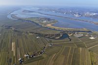
The Große Brack is a testimony of the ongoing struggle of the Altländer against the threat of floods. In the area of Hinterbrack, Wellenstraße and towards Leeswig, observed from the sky, one can see how the plots of land are aligned with the old dyke lines of protective dykes, which often had to be rebuilt due to the repeated dyke breaches.
Today, the Große Brack is a biotope and nature reserve. The large area of water with reed areas, willows and alders is reminiscent of the original nature as we can imagine it from the time before the Hollerkolonisation.